

Norman Maudsley writes: Unable to organise a lift to the starting point of our usual Wednesday walk, Brian Ferns and I decided to use the good public transport we are blessed with in Dawlish, catching a No 2 bus from Dawlish heading out towards Exeter to commence our walk from the A379 under the M5 flyover.
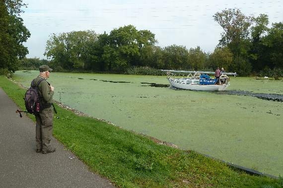
Making our way to join the Exe Valley Way, we headed north up the Exeter canal which was completely blanketed with green duckweed, caused by the hot weather we have been enjoying here in the south west. We paused to watch a boat heading up the canal as though it was an icebreaker ploughing through pack ice.
As we walked we were passed by numerous canoeists, a popular activity on the canal.
Heading for Bridge Road with its extensive roadworks, the swing bridge was currently in the open position. We made our way safely through the works. It appears that the new walkway and cycleway will run at a lower level, with the present route incorporated into the main road.


Crossing the River Exe we joined the path down to the left bank of the river on to our destination Exmouth.
At the start of Exeter’s history the River Exe was tidal and navigable up to the city walls enabling it to be a busy port. In 1286 the Countess of Devon, Isabella de Fortibus, built a weir across the river to power her mills.
This stopped boats reaching Exeter. In 1653 Exeter traders employed John Trew of Glamorgan to build them a canal to by-pass the weir and re-join the River Exe in the city centre.
Back to our walk, the route was blocked by house building within the Topsham Gap which the town has fought hard to keep as a green area.
Diverting across playing fields we found the path we needed to rejoin the left bank of the Exe and soon we were entering Topsham, a pretty little town which was once the second-busiest port in England.
The native Celtic settlement of Topsham became the port of the Roman city of Isca Dumnoniorum (Exeter) in the first century AD and continued to serve it until the Roman occupation of southern Britain ceased about the year AD400.
In the seventh century, Saxon rule in Devon saw the settlement grow into a considerable village.
Topsham’s position, offering a sheltered harbour to seagoing trade, enabled it to thrive as a centre for both fishing and shipping. As you walk through Topsham you will see many Dutch-style houses, dating from when Topsham was an important cotton port.
Keeping close by the river on quiet paths and narrow streets we continued along the walkway out of town to turn inland to join the newest section of the Exe estuary trail that passes over the River Clyst.
At first it seems strange that the up-river view is blocked by high boarding with numerous rectangular openings letting passers-by view the many species of birds within this wetland area.
Meeting a T-junction, the River Exe trail will either take you back to the Cotswold store or on to our next destination – Exton.
Walking down the trail the estuary gives an impression of tranquillity and timelessness, yet it is always changing, linked to the tides and currents and our ever-changing climatic activity.
The estuary is a unique environment providing habitats for a range of wildlife including thousands of migratory birds which visit each year, and is designated a Site of Special Scientific Interest. It is estimated that during the winter months 25,000 migrating birds use the estuary to rest and feed on.
Arriving in Exton we passed the Puffing Billy hostelry and took advantage of the shelter on the station platform with its fantastic view across the wide Exe estuary to enjoy our refreshments.
Moving on we reached the Commando Training Centre RM, the principal military training centre for Royal Marines.
Established in 1940 as the Royal Marines Depot Lympstone, it was renamed the Commando Training Royal Marines in 1972.
Reaching the village of Lympstone, we simply had to go down to the foreshore and view Peters’ Tower, an Italianate riverfront brick tower built about 1885 by WH Peters as a memorial to his wife.
On a nice sunny day do not be surprised to find the locals drying their washing out on the lines on the foreshore.
Brian then led me to a narrow path up at the railway height, clear of the cyclists on the other side of the railway and high above the estuary level. This was completely new to me and is shown on the OS Map as East Dart Way.
Quite close to Exmouth we noticed a blue plaque which informed us of the existence of Lower Halsdon Farm. This had been gifted to the National Trust by Stanley Long (1918-2001) who had generously given the 44.5 hectares of land in 1995 in memory of his late wife and his parents and Sir James Garbutt Knott.
The land will be held by the National Trust to preserve in perpetuity the open views across the Exe estuary and remain an important area for the overwintering migrant birds. We must all be grateful for the generosity of such people.
Soon we arrived at Exmouth with nine interesting miles under our boots. There was just one last thing to do, find a cafe to enjoy tea and cake. This resulted in one false start when the girl left in charge decided to ignore our presence in a cafe. She stood two-feet from Brian and myself and continued to plan a night out with her friend. She had a lot to learn about customer service – we walked out.
Further along the street we had good service. Refreshed we made our way way home via Countess Wear making the most of our bus passes. Another excellent day.
On Sunday, 11 Teignmouth and Dawlish long walkers car-shared out to South Brent to start a walk led by voluntary leader Charmaine Hartley, ably assisted by husband Frank who took on the important role of back-marker, making sure no walkers got lost during the walk.
Our start point was the car park in the station yard. The line had opened in 1848 with the station closing in 1964.
The parish church of Brent is St Petroc’s, dedicated to the sixth century saint who founded both the local parish church and Buckfast Abbey.
The manor of South Brent originally belonged to Buckfast Abbey. At the dissolution of the monasteries it was bought by Sir William Petre, 1505-1572. With insider knowledge, he had checked the monasteries before their closure and picked some of the best.
He became Secretary of State to Henry VIII, and to his children Edward VI, Mary I and Elizabeth I – all unbroken service.
He retired a rich man owning 36,000 acres of Devon, the head of a Devon family with the father being MP for Dartmouth.
Rising above Brent village is Brent Hill which is composed of ironstone, which attracts lightning. In the past iron was mined on the hill together with magnetite which was used in the manufacture of compasses.
In Drake’s time a beacon was built on top of the hill, which was lit to signal the approach of the Armada.
Heading off we first went to the village of Lutton where, for those readers interested in the postal service, one of a small number of red wall-mounted post boxes bearing the name Edward VIII can be seen.
Now moving on to Didworthy where in the early 1900s there used to be a hospital for those with chest infections such as TB. It had an excellent reputation for a high recovery rate due to the quality and purity of the air. It opened in 1902 and closed in 1968. Didworthy House is now privately owned.
Moving on to Shipley Bridge we enjoyed our morning coffee break on yet another sunny day for a walk taking in the southern moorland.
This area historically saw the extraction of clay, and the long wall with numerous gaps is the remnant of clay-drying sheds where wagons were loaded for onward transport.
Early in the 19th century visitors would have seen the production of naphtha, distilled from peat to make a flammable liquid – crude oil.
We now enjoyed some moorland walking with very little boggy land. On this occasion it was a bit squelchy, with numerous moorland drainage streams to negotiate as we crossed the area.
Here we enjoyed our packed lunches with long distant views stretching out all around. Who could wish for a better spot to rest, eat and relax with a friendly group of walkers?
Time to head back to the cars we headed via Lydia Bridge, an old packhorse bridge demonstrating the history of the moorland. Nearby stood a mill known to be rebuilt in 1669 after a fire.
We finally arrived back at the cars with 8.4 miles under our boots and memories of walking through history on the Sunday walk.
It was then time for home with some of the group calling into the Buckfast steam railway complex to enjoy tea and cake, bringing a satisfactory end to the day’s walk.
Comments
This article has no comments yet. Be the first to leave a comment.